Saturday, June 22, 2013

June 20 - 21, 2013: MIM Day 5 and 6, Hamilton to Lochsa Lodge to Lowell

Greg was camping at an RV place on the other side of town, so we picked him up as we passed by. After a mile or so we found the bike path and stayed on it for the 37 miles or so to our turn onto US 12 in Lolo. Thanks to a steady tailwind, we made good time and used minimal energy. The weather was cool and very cloudy, but we did not encounter any rain on that leg of the trip. 

When we arrived in Lolo, we had lunch in a restaurant/saloon/casino -- one of many in Montana. The weather was still just as cool and unpleasant as it had been all day as we got back on our bikes to start the climb up the famous Lolo Pass, which had come close to being the undoing of the initial Lewis and Clark expedition. There are very limited services on this portion of US 12, and we had run into some rain on the long approach to the pass, so we were more than ready for a warm break when we reached the Lolo Hot Springs resort. At that point we were still about seven miles short of the top of the climb.

After warming up and refueling, we started the more difficult section of the climb. By the numbers this pass should not have been as hard as previous ones, but I found it to be the hardest of the trip so far. It was cold and windy and the grade tilted up to 5, 6, or 7 percent for extended portions. Just as we finally made the summit, the sky opened up. Luckily, once again, there was a handy rest area right there, so we ducked in to warm up and to put on our rain gear. When it let up, we started our descent, still wearing our rain gear in spite of the fact that it was barely raining any more. Underneath our rain jackets and pants were many layers of sweat-soaked clothing, thanks to the exertions of the climb.


Taking refuge from the cold and rain in a convenient visitor center. Inside there were many displays about Lewis and Clark as well as the local area.

Waiting out the rain.
At the top of the pass, we left Montana and entered Idaho. The road condition was terrible by comparison to that of neighboring Montana. In conjunction with the wet pavement, switchbacks, lack of ride-able shoulder, 6% downgrade, and more than a smattering of large trucks, I quickly determined that in spite of feeling increasingly chilled, I had to keep my speed down. By the time I reached the end of the steepest part of the descent, about five miles, I was very cold indeed. I had to find a way to warm up, or stop to do a road-side replacement of my cold, wet clothing. I decide to try to warm up by pedaling hard. That worked to some extent, and the sun came out by the time I reached the beautiful Lochsa Lodge. In the ten minutes that it took for Fred and Greg to catch up, I had gotten my rain gear off and was feeling much better.

The day's ride was 82 miles with six and a half hours in the saddle and 3,000 feet of climbing.

If you are ever looking for a really nice, very reasonably priced get-away, you can't go wrong with the Lochsa Lodge. There is no cell service or television (you can borrow a DVD from the library at the front desk). The only thing connecting you to the outside world is wifi at the main building. Speaking of the main building, a large portion of it is the dining room, which served us an excellent dinner and breakfast. Both featured huckleberries in some form or another. Our waitress at dinner assured us that huckleberries are "like blueberries, but a thousand times better." In spite of the fact that my stomach was still not right, I had a big dinner, which was probably not wise.


The main building at Lochsa Lodge
At breakfast the following day I had half an Immodium, along with a bowl of oatmeal with berries, which was good but there were plenty of other choices I would have made had my gut been in better shape. After breakfast I took my time getting ready, just to be sure I would not be stuck somewhere along our 65 mile service-free route answering an urgent call of nature. I stuck a new roll of toilet paper in one of my panniers, just in case!


Our cabin at the Lodge. Inside, everything is modern and new. Really nice! 
There were plenty of other people there, but it never felt crowded.

Some more photos on the grounds:


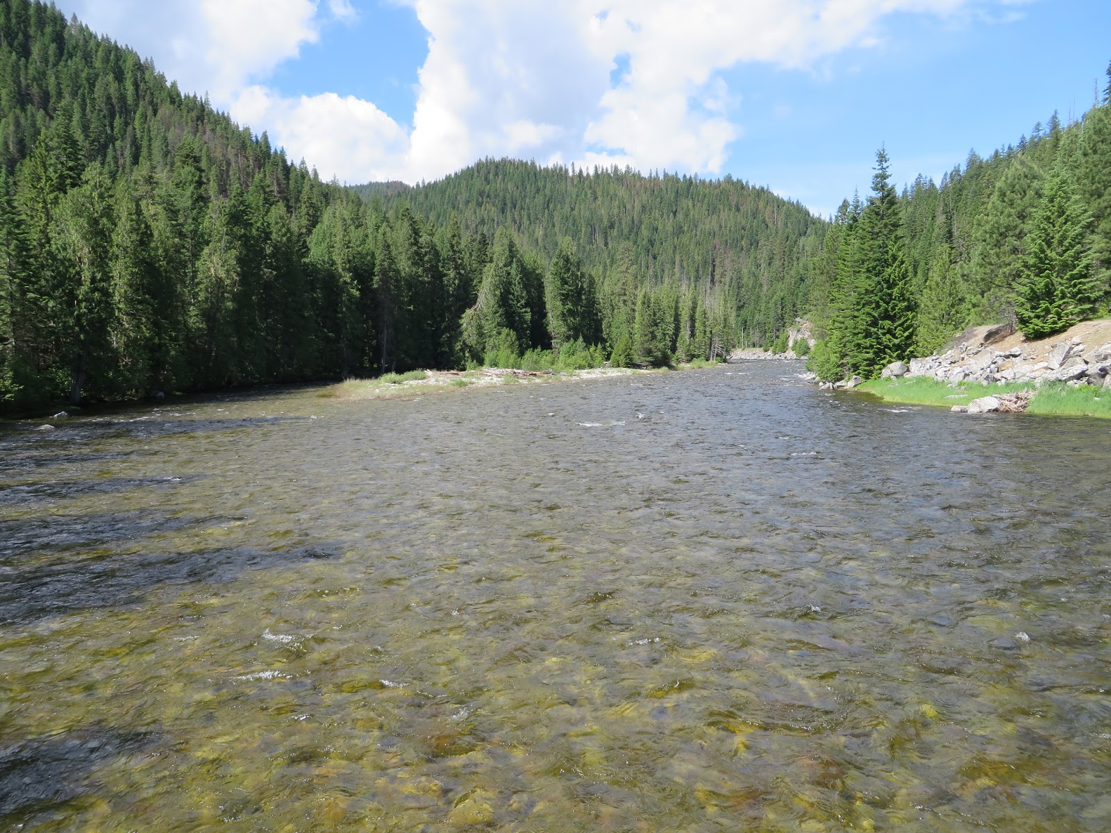
The day's route was simply 65 more miles down US 12. It started out cool, but SUNNY, in stark contract to the past couple of days. In addition, there were no climbs and our destination was 2,000 feet lower than our starting point. The entire route ran alongside the beautiful, crystal-clear Lochsa River, bounded by spectacular forested hillsides. We stopped several times to better enjoy it.


At about mile 50 or so, the sky clouded over, the slight head-wind freshened, and rain started falling. We put on our rain gear as three river rafts full of adventure-seekers finally caught and passed us (temporarily). Ultimately, they caught up with us again at Ryan's Wilderness Inn, where we are staying for the night, and where their outfitter brought them at the end of their white water raft excursion.


The ride was 65 miles, four and three quarters hours of saddle time, and just 200 feet of climbing.

Tomorrow is the seventh day of the bike trip and if things go as planned, it will be a 30 mile "rolling recovery" day.


Thursday, June 20, 2013

June 19, 2013: MIM Day 4, Wisdom, MT to Hamilton, MT

At present, I am lying in bed in my motel in Hamilton. I am feeling a bit nauseous, apparently a side effect from lunch -- a tuna melt and large mound of fries. Pretty much the only time I eat significant amounts of fried food is on these bike trips, and this very result has occurred before. I don't feel like I'm about to hurl, but I didn't feel well enough to accompany Fred to the nearby Bitteroot Brewery for beer and more food. I didn't think I would be up for this post, either, but here I am.

Today was eventful:
  • We invited Greg (a Trans Am Route cyclist whom we met a couple of days ago) to ride with us today.
  • Right out of the gate we hit a strong headwind and we were glad to have a third person to take turns at the front of the line for the first 15 miles or so.
  • As we started our climb up Chief Joseph Pass (we went over the top at 25 miles), it started raining and pretty much kept raining for the remaining 50 miles of today's ride. Fred had wisely insisted on a stop to get our rain gear on when we felt the first drops.
  • After going over the pass it got suddenly colder, thunder started rumbling, and the rain turned into sleet or hail or something else that is bad. Luckily we came upon a Montana Rest Area, complete with heated information cabin, a mile later. We took refuge there until the thunder abated and the rain became lighter and returned to completely liquid state. While there, Greg and I both added yet another layer of clothing. For me that meant: base layer, short-sleeve jersey, windbreaker, polartec-lined shirt-jacket, and my rain jacket on the top. I was already wearing SealSkinz neoprene socks over woolen socks as well as neoprene gloves.
  • It was 43 degrees when we left the shelter and started the descent of 3500 feet. (The pass is at 7200.) I quickly left the others behind, searching for the happy medium between the chilling effect of a fast descent and the desire to get it over with as soon as possible. That turned out to be a speed of 30 or so, except for switchbacks, which I took much slower. I got down to the store in Sula several minutes before my companions, and took some photos of their arrival (below).
  • When I removed my gloves I found that one of my fingers was numb. Apparently the neoprene gloves were not the answer, so during our warm-up at the store I switched to half-finger polartec gloves that convert to mittens. I also switched from knee warmers to full leg warmers under my rain pants. Officially, I was now using all the cold weather and rain gear in my possession, and it worked out well. Even though the rain eventually seeped through the mittens, my hands remained comfortable. My torso felt cold for a few minutes after each stop, but after pedaling a little I felt good. My feet felt slightly cool from time to time, but not uncomfortably so.  
  • From the time we crested the pass, we were descending. The first 12 miles was at a downgrade that varied from three to six percent. The only energy required was to stay warm and to feather the brakes. The remaining 38 miles was easy pedaling at 15 MPH or faster because of the slight downgrade and lack of appreciable wind.
  • I had the first flat of the trip. My front tire picked up some glass about 10 miles from our destination. There was a handy covered porch nearby, so we were able to fix it in comfort and we were back on the road quickly.
  • Stats: 73 miles, riding time 5 3/4 hrs, 2000 feet of climbing.
  • It may be cold and wet, but we are having a great time! After all, it is days like this that make it "adventure" cycling.
Because of the weather we took few photos. There are a couple at our overnight place in Wisdom, one at the Montana Rest Stop, and a few of Fred and Greg arriving in Sula (Fred replaced the Dollar Store shower cap he was wearing earlier with a makeshift Arabian-style rain hat. Once a fashionista, always a fashionista.)


June 18, 2013: MIM Day 3, Dillon, MT to Wisdom, MT

Last night we stayed at the Motel 6 in Dillon. We mistakenly thought that there was a little breakfast of some kind, but in the morning we discovered that the only offering was coffee. We had decided to try to get an early start, so we ended up riding out without breakfast. The first on-route services were not until mile 50, after going over two passes, so we had to make do with sports drink and a few energy bars that I had available.

We had two notable encounters on the road. The first was at about five miles, a scruffy Momma Cass type sitting by the side of the road. She got up and said something to me,but I didn't understand and rode by. Fred, on the other hand stopped to see what she wanted. Apparently there is a Rainbow gathering taking place just outside Jackson, the town on our route at 50 miles. More about that in a bit.

The second encounter was with an old rancher at around 25 miles. We had pulled off the road for a rest right across from his house, and a few minutes later he drove over on a heavily used ATV. We had a wide ranging conversation about everything from weather, to local animal predators, to cyclists he had assisted over the years, to the Rainbow Gathering taking place near Jackson. He assured us that the second of the day's passes was much easier than the first (which wasn't that bad when compared to yesterday's). With that encouragement, we proceeded on our way.

We were stopped to take some photos after the steeper part of the second pass when a caravan of a dozen or more law enforcement SUV's sped by. Fred's guess was that they were converging on the area to keep an eye on the Rainbow people. Later, at the restaurant in Jackson, we talked to a couple of the officers, who confirmed that to be the case.

Also, while at the restaurant waiting for our food, we met several young cycle tourists who are taking roughly the same route we are. Our food finally arrived, and as soon as we finished we headed out. The previously partly cloudy skies had darkened, the wind had come up, and it was raining over the mountains to our left. We felt a couple of drops in our first mile, but as it turned out, the wet stuff stayed out of the valley. The last 18 miles of our ride to Wisdom, MT, our destination, was mostly a downgrade and we had a significant tailwind. The result was a pace of between 25 and 30 MPH the whole way. Quite a difference from our earlier crawl up Badger and Big Hole passes before lunch.

When we pulled up to our lodging, a couple on a tandem, pulling a trailer, was walking their rig around the corner heading in the direction from which we had just come. The wind by this time must have been 25 MPH or so and the sky was gray and threatening. I went over and said flat out that I hoped they were not planning to try to ride that way. It didn't take much to convince them to wait an hour or two to see if the squall would pass.

We then went inside to check in, but couldn't pay for our rooms because the entire town was without electricity. In addition, we could not get cleaned up or do our daily laundry because the well pump that provides water was out as well. Fred took a nap until our agreed-upon time to go for dinner, and I read a little and determined that there was no cell service -- not even when there is electricity. (The power came back on at about 5:15, shortly after we walked into the restaurant. We spent the next few hours over there, mostly talking to Greg, a solo Trans Am Trail rider we had met the day before in Dillon. We also spend a few minutes talking with a pair of women about our age who have been doing an annual three week tour similar to what Fred and I have been doing. I think this is just their second stage, though, and they are riding recumbents. They will definitely have their work cut out for them on some of the passes!

The restaurant had wifi, so I sent Kathy an email to let her know we arrived and are ok, but without wifi over at our rooms, this post will not go out until tomorrow.

The day ended up about 66 miles over four and a half hours in the saddle, with 3,600 feet of climbing.

Here are some photos from today's ride. The photos of the flowers in the field and the close-up are dedicated to my personal Flower Goddess back home.


Tuesday, June 18, 2013

June 17, 2013: MIM Day 2, Ennis MT to Dillon, MT -- Let's wake up those climbin' legs!

We left Ennis at about 8:50 this morning. Fred tells me that it was 45 degrees, but it was really quite pleasant, sunny with no wind at all. We started our climb in less than three miles and rapidly locked in at 7%, where it remained until the summit at mile 11. That was 90 minutes later. There was a short flat stretch, a few hundred yards maybe, before starting a descent, also 7%. Fred has a pact with his wife Pat to keep his speed under 30 on these descents, but I have no such agreement with Kathy and enjoy fast descents when conditions (visibility and road surface) are good. Nevertheless, I did not want to get too far ahead of Fred because I didn't want to have to pedal back up if he ran into an issue, so I stopped once to let him catch up, and slowed down again as I got close to Virginia City. Even so, it took less than ten minutes to get down the mountain that took us 90 to get up. I stopped altogether at the edge of town to investigate an ancient, abandoned gas station. Eventually I was able to discern a price of 41.9 cents on one of the pumps. There were only the three price wheels, so these pumps could not have gone beyond 99.9 cents under any circumstances.

Virginia City is done up as a tourist attraction, with lots of antique stuff in buildings that look as I imagine they might have at the end of the 19th century. I am partial to that period as the fashionable gents of the time sported nose ticklers similar to my own. Anyway, it is not overly commercial and attractive in its own way. Regardless, we looked around from our rolling bicycles and were not tempted to stop for more than a couple of photos.

From there we continued a shallow descent to Sheridan, MT, where we had lunch, after about three hours of riding. Back on the bikes we had a pleasant surprise -- an eight mile 2% downgrade that had us effortlessly rolling along at 20 MPH into Twin Bridges, where we turned toward Dillon, our destination, 28 miles down Hwy 41.

About 15 miles from Dillon we stopped to chat with Park (his name), a 23 year old man from South Korea who is riding the Adventure Cycling Trans Am route from Astoria, Oregon to the Atlantic shore in Yorktown, Virginia (4,200 miles). He gave us each a folding card that explains that this bike tour is an item on his 28 point bucket list, which surely must have lost something in translation.


Park's "Bucket List"

Shortly after this encounter, the road morphed into a long series of rollers that I found to be an unexpected and undesired change this late in the day's ride. Fred and I both started have periods of fatigue and energy, but completely out of sync with one another, and for the first time the weather actually felt a bit warm. At any rate, we made it into Dillon and came up beside another cycle tourist, Greg, who is close to the end of the same route as Park, but in the opposite direction. He was quite congenial, and we may encounter him again over the next few days. He is a bit younger than we are and is camping instead of doing motels as we are.  Dinner tonight was uninspired Chinese, followed up by some local "Scotch Ale" we acquired at a convenience store.

Today's ride was about 72 miles, a bit over five and a half hours on the bike, and about 2,800 feet of climbing.

We had some especially nice views of the valley as we climbed out from Ennis this morning. Here they are, along with others from the day.


Across the street from our hotel in Ennis


Probably all for the best that they were not open this early in the day. I have more than enough bike jerseys, but I might have been tempted to add one of these to the collection.


This is a house with a view that one could never tire of seeing.


Beautiful view of the valley out of which we were climbing.


A most welcome sign after our 90 minute, 7% climb.


On the way into Virginia City. All sold out of 41 cent gas.


Virginia City definitely caters to tourists, but relatively tastefully.

Lunch spot in Sheridan, MT